Commons:Graphic Lab/Map workshop
| Illustration Workshop | Map Workshop | Photography Workshop | Video and Sound Workshop |
 Map workshop
This workshop is part of the Graphics Lab, a project aimed at picture retouching to improve the graphical content of the Wikimedia projects. More information about the lab can be found on its main page and requests pages (Illustrations ; Photographs ; Maps ; Video and Sound). To ask questions or make a suggestions, see the talk page of the graphic lab page.
This specific page is the requests page for the Map Workshop. Anyone can make a request for a map to be created or improved. The standard format for making a request is shown below, along with general advice, and should be followed.
Make a request
Use the following template when making a new request, replacing the examples with your image(s) and request(s):
<gallery>
 IMAGENAME.EXT|Description of image
 IMAGE#TWO.EXT|2nd image (If there is one)
 ETCETCETC.EXT|Don't request too many at once, though
</gallery>

;Request:
: Details of your request go here… --~~~~
;Graphist opinion(s):
See also[edit]
| SpBot archives all sections tagged with {{Section resolved|1=~~~~}} after 7 days and sections whose most recent comment is older than 185 days. For the archive overview, see /Archive. The latest archive is located at /Archive/2023. | |
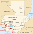
Map of volcanoes in Guatemala[edit]
-

Map of the volcanoes in Guatemala
-

Map of Guatemala in Inari Sámi
-
combined


Article(s): Listo Guatemala tullâvaarijn
- Request
- I would like only the Guatemalan volcano symbols and labels in the first image to be added to the Inari Sámi map of Guatemala in the second image and saved as a new file so we can use it in an article on the Inari Sámi wikipedia. The volcano labels are missing the diacritics in the gif and the following labels would need to be fixed: Santa María, Atitlán, and Tolimán. I would also appreciate if the symbol and label colors could match the SVG image color scheme better than the bright red of the GIF. Takkâ! :) --Yupik (talk) 09:04, 11 January 2023 (UTC)
- Graphist opinion(s)
 Done, though the inclusion of town names alongside volcanos entailed a degree of awkwardness SmallJarsWithGreenLabels (talk) 00:50, 2 June 2023 (UTC)
Meitei language geographical distribution map[edit]
-
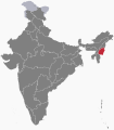
Manipur state
-

Assam state
-

Tripura state
-

Northeast India
-

Sylhet division (not Sylhet district)
-

Sagaing region
-

Mandalay region
-

Yangon region
-


- Request
- Hello! May I request you to make a map in which (1) "Manipur" is in the darkest colour, (2) Assam and Tripura states in a lighter colour, (3) remaining "Northeast Indian states" in the little lighter colour, (4) Bangladesh's Sylhet division (not to be confused with Sylhet district) and the Sagaing region of Myanmar in a lighter colour, (5) the Mandalay region and the Yangon region, File:Ayeyarwady Region in Myanmar.svg, File:Bago Region in Myanmar.svg, File:Shan State in Myanmar.svg & File:Kachin State in Myanmar.svg in a little lighter colour, which is for the regions where Meitei language is spoken with respect to concentration of population? Fortunately, the said portions of areas in the 3 neighboring countries are demarcated properly in various svg maps available in the Commons. --Haoreima (talk) 16:09, 13 March 2023 (UTC)
- Graphist opinion(s)
- @Haoreima: I have created an SVG map as per your request (Meitei language distribution.svg). However, the subnational boundaries are fairly inaccurate due to the inherent inaccuracy in the base map (Blank Map World Secondary Political Divisions.svg). You may consider using Meitei language distribution.png, which is much better. --Sbb1413 (he) (talk • contribs) 15:47, 18 July 2023 (UTC)

SVG map I've created

PNG map I've found in English Wikipedia
Simple map(s) of Finnish Defence Forces Areas of Responsibility from early 1950s[edit]
-

A potential base map

Article(s): en:User:Ljleppan/Polttoainehankinta
- Request
- (Moved from Commons:File requests)
- I'm not certain what the best source map would be, but I'd appreciate a Commons-compatible version of the map of Figure 6 (page 37) of this PDF (also accessible via this link) for the draft currently at en:User:Ljleppan/Polttoainehankinta. In addition to the Areas of Responsibility, it would be good to show the locations of en:Helsinki, en:Porkkala and a few of the larger cities (Perhaps en:Turku, en:Vaasa, en:Oulu, en:Rovaniemi and en:Ivalo if possible without sacrificing legibility?).
- I'd also greatly appreciate Commons-version of the map(s) in Figure 5 (page 31) of the same PDF, but that's less of a priority.
- Graphist opinion(s)
Creating Maps of Talukas(sub-district) of Gujarat[edit]
- Request
I have a request for making maps of Talukas(sub-districts) of Gujarat districts.Can you make some maps of Talukas of districts of Gujarat, India.
Here are the talukas list - Talukas of Gujarat: link
-

Similar to this(Ahmedabad district talukas map)

Checkout Some available maps:
- [File:Gujarat Talukas Map 2011.svg] but it's old version. "In 2013 some new District has been created".
- [1]
- [2]
- [3]
- [4]
- [5]
- [6]
DSP2092 (talk) 06:21, 27 March 2023 (UTC)
- Hi, I found this source, seems updated to 2018, but the administrative division is different than the one in your images (see here a quick export). Is it correct? In case i can generate the map. The best solution would be to find geographical shapefiles from official indian sources Sette-quattro (talk) 07:32, 31 March 2023 (UTC)
- Yes it's a Gujarat Sub-districts (talukas) map.If there's a full map of Gujarat.It's not a complete map. DSP2092 (talk) 17:06, 2 April 2023 (UTC)
- Yes there is the whole country, my question is if the division of sub-distritcs is correct. Do you need one map of all the sub-dostricts of Gujarat, or multiple maps (e.g. one per district)? Sette-quattro (talk) 20:31, 5 April 2023 (UTC)
- Yes it's a Gujarat Sub-districts (talukas) map.If there's a full map of Gujarat.It's not a complete map. DSP2092 (talk) 17:06, 2 April 2023 (UTC)
- Graphist opinion(s)
![]() Request taken by Sette-quattro (talk) 16:12, 6 April 2023 (UTC)
Request taken by Sette-quattro (talk) 16:12, 6 April 2023 (UTC)
- @Sette-quattro, I have found some maps - link but it needs some editing like above map. DSP2092 (talk) 16:36, 17 June 2023 (UTC)
13 Colonies map into US English[edit]
-

Map of the Thirteen Colonies what appears to be German

Article(s): en:Thirteen Colonies, en:United States, en:European colonization of the Americas, en:British colonization of the Americas, en:United Colonies,
- Request
- Could someone make a version of this map in US English?
- The idea is to have a good map in English of the Thirteen Colonies as they existed in 1775 before the US Declaration of Independence: a map that is not anachronistic—that is, a map that doesn't show boundaries of US states that did not exist at the time. إيان (talk) 23:30, 2 April 2023 (UTC)
- Graphist opinion(s)
 Half done – I have translated most German elements into English, except Sankt-Lorenz-Strom, which I have not translated yet for some reasons. Here is the English-version map: Thirteencolonies politics cropped-en.jpg. --Sbb1413 (he) (talk • contribs) 17:42, 15 June 2023 (UTC)
- Thank you Sbb1413! Is there anyone who can change 'Sankt-Lorenz-Strom' to 'St. Lawrence River'? إيان (talk) 20:34, 25 August 2023 (UTC)
Chronological map of NATO membership[edit]
Article(s): en:Enlargement of NATO
- Request
- This animated GIF of the chronology of NATO membership looks awful. I've again had to update it manually today, and really with it could be recreated either as a higher resolution GIF with smoother animation, or perhaps an animated SVG that might be both cleaner and easier to update. The only small trick is the borders in Europe should match the year each member joined. Thanks! -- Patrick, oѺ∞ 18:23, 4 April 2023 (UTC)
- Graphist opinion(s)
- As far as I know, Mediawiki can't render animated SVGs. SmallJarsWithGreenLabels (talk) 00:01, 2 June 2023 (UTC)
- That's fine, a high resolution GIF would also be a significant improvement. Or an OGG video even. The one we have is just garbage! Patrick, oѺ∞ 14:39, 2 June 2023 (UTC)
- I think it's important for it to be easy to edit, so an OGG doesn't sound good. Personally I couldn't care less about the resolution, but what I really dislike about this gif is that the year label is all the way across from Europe, so it's impossible to keep track of without frantically looking back and forth between them. SmallJarsWithGreenLabels (talk) 11:34, 3 June 2023 (UTC)
- Hi there, just reiterating that a superior GIF file would also be a welcome option, particularly as news is breaking that Sweden's accession may be in the near future, which will necessitate another edit to the lousy old GIF. If I had the ability to create this, I might start with File:EC-EU-enlargement animation.gif, which shows what this could be like. Perhaps the U.S. and Canada could be an insert? There's also been the request to include frames showing when Trieste joined Italy in 1953, Saarsland rejoined West Germany in 1957, and Malta became independent in 1964 if possible. Thank you to anyone who can help! -- Patrick Neil, oѺ∞/Talk 15:57, 11 July 2023 (UTC)
- I think it's important for it to be easy to edit, so an OGG doesn't sound good. Personally I couldn't care less about the resolution, but what I really dislike about this gif is that the year label is all the way across from Europe, so it's impossible to keep track of without frantically looking back and forth between them. SmallJarsWithGreenLabels (talk) 11:34, 3 June 2023 (UTC)
Blank map of Kampala[edit]
Request cancelled: I need to find a reference map that can be used free of rights. Exilexi (talk) 17:16, 25 August 2023 (UTC)
-

Current map of Kampala (OSM screenshot) on Commons

Article(s): en:Battle of Kampala (& other linguistic versions, especially fr:Bataille de Kampala
- Request
- Hi! I'd love to have a legible SVG map of Kampala with its main hills/districts and roads. My immediate use is to make a map of the en:Battle of Kampala (I'll try to do it on my own, but have never done this before, so maybe I'll call for help again for that specific overlay) but the map will be useful for anything related to the city. --Exilexi (talk) 09:29, 18 May 2023 (UTC)
- Reference material: https://www.researchgate.net/figure/Map-of-the-hills-of-Kampala-Mengo-including-the-boundaries-of-the-Kibuga-and-colonial_fig2_321723920 has the main hills of the city.
- Graphist opinion(s)
Exilexi I can help you with this map and also later on if you need help with the battle map
- I will take this if you will be available thru out the whole process?
Have you checked the researchgate link if it has any copyright, because then we can only use it as an information source? --please ping me-- Goran tek-en (talk) 17:02, 14 August 2023 (UTC)@Exilexi I do need your knowledge and assistance to be able to create this so please reply here, thanks. --please ping me-- Goran tek-en (talk) 12:37, 20 August 2023 (UTC)
Exilexi As I can't get in contact with you I withdraw my interest for working on this. --please ping me-- Goran tek-en (talk) 17:05, 25 August 2023 (UTC)
- Hi! For some reason I was only pinged on the first and last messages (not the August 20 one) and since I'm on holidays until August 28 I didn't check my notifications as much as usual. I just checked and it seems that the researchgate link cites a book of archives from the 1950s and 1960s, so not free of rights. Really sorry for the bother, I'll try to find better sources and potentially figure this out myself as I've gotten basic Inkscape training in the meantime :) Exilexi (talk) 17:16, 25 August 2023 (UTC)
Puerto Rico[edit]
-
_(US50)_(-grid).svg/120px-Hawaii_in_United_States_(zoom)_(US50)_(-grid).svg.png)
Description of first image
_(US50)_(-grid).svg)
Article(s): Hawaiʻi on Wiktionary; A lot
- Request
- I suggest adding Puerto Rico to the United States, unless it's not part of the United States.
- Puerto Rico is part of the United States. People wonder why many Americans don't know it- well there's your answer. Just because "(US50)" appears in the title doesn't change how this image is actually used- see Hawaiʻi on Wiktionary. The caption there reads: "Hawaii in respect to the rest of the United States". You're giving people a stupid map that would need to be presented in a qualified way, and then that map is being used to imply that this is a map of the whole USA. You now get to choose whether WMF will continue to deceptively imply that Puerto Rico is somehow not part of the United States. Don't bring your decolonization ideological stuff at me when Russia still has Siberia and China has Tibet. As if! Yes Puerto Rico has got a special status. But they voted to become a state a few years ago (it wasn't accepted by the US Congress yet, this is just a fact that tends to discredit any "decolonization" ideological silliness). So Yes, it's the USA. Get off your high horse and show the people the full United States. --Geographyinitiative (talk) 22:26, 18 May 2023 (UTC)
- Graphist opinion(s)
- There are locator maps of Puerto Rico within the United States, similar to the above locator map of Hawaii. Take a look at the following maps:
-
_(US49).svg/120px-Puerto_Rico_in_United_States_(zoom_+_special_marker)_(US49).svg.png)
Puerto Rico in United States (zoom + special marker) (US49)
-
_(US49+1).svg/120px-Puerto_Rico_in_United_States_(zoom_+_special_marker)_(US49+1).svg.png)
Puerto Rico in United States (zoom + special marker) (US49+1)
-
_(US49).svg/120px-Puerto_Rico_in_United_States_(zoom)_(US49).svg.png)
Puerto Rico in United States (zoom) (US49)
-
_(US49+1).svg/120px-Puerto_Rico_in_United_States_(zoom)_(US49+1).svg.png)
Puerto Rico in United States (zoom) (US49+1)
_(US49).svg)
_(US49+1).svg)
_(US49).svg)
_(US49+1).svg)
- Also, you should not blame WMF for ignoring Puerto Rico as part of the US. It is generally not shown along with the 50 states and the federal district as US overseas territories are excluded from most maps. There's no "decolonization" ideology whatsoever on this matter, just a matter of convention. --Sbb1413 (he) (talk • contribs) 16:52, 15 June 2023 (UTC)
- @Geographyinitiative: Sbb1413 (he) (talk • contribs) 15:51, 18 July 2023 (UTC)
- Pardon me, my comment above is a little bit intense! All I mean is that I feel that 1) if Puerto Rico appears on a map, 2) and the map does not show Puerto Rico as part of the USA, 3) then there should be a good reason, or a specific purpose for that map, rather than as a general map "of the USA". Hence I renew my request for the update to that map showing Hawai'i without showing Puerto Rico as part of the USA. --Geographyinitiative (talk) 16:16, 18 July 2023 (UTC)
- In Description of first image, the position of the Hawaiian Archipelago inside the box is wrong. The islands need to turned to their correct geographical position. --Multituberculata (talk) 20:38, 20 November 2023 (UTC)
Venezuela president recognition map[edit]
-

"Map showing the recognition of Juan Guaidó as acting president of Venezuela:"

Article(s): en:Responses to the Venezuelan presidential crisis
- Request
- Hi! Users that are familiar with the topic know that the presidential crisis in Venezuela has been ongoing for four years, and it hasn't been until recently that it seemingly has come to an end. Naturally, this map: File:Venezuela president recognition map.svg has changed drastically since its beginning in 2019. To reflect these changes over the time, I've thought that an animated file, such as a gif, would be ideal. Are there contributors that could help with this? Many thanks in advance! --NoonIcarus (talk) 22:47, 12 January 2023 (UTC)
- I forgot to ask: if possible, an important aspect to include would naturally be the date where the current frame stands. Thanks again! --NoonIcarus (talk) 10:20, 15 January 2023 (UTC)
- Graphist opinion(s)
Copied from Video and Sound Workshop by 多多123 20:24, 21 May 2023 (UTC)
- @NoonIcarus: I think it's a good idea, although looking at the changes, the only large changes I can notice are all the south america countries turn blue but thats about it. Almost all others stay the same throughout the entire thing.
Japanese Empire 1939[edit]
-

Japanese Empire, 1939
-

-

-


Article(s): Manchukuo, etc.
- Request
- (1) Saipan should appear these four maps in the same way it appears on File:Mengjiang map 1939.svg. (This is because Saipan was part of the Japanese Empire in 1939 and not part of the USA yet.) (2) Vladivostok is misspelled as 'Vladivostak'; this should be corrected. --Geographyinitiative (talk) 00:16, 1 June 2023 (UTC)
- Graphist opinion(s)
- Note fixed spelling. Other issue still needs addressing. SmallJarsWithGreenLabels (talk) 23:23, 1 June 2023 (UTC)
- Done SmallJarsWithGreenLabels (talk) 23:50, 1 June 2023 (UTC)
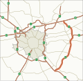
Milan highways[edit]
-

A50
-

A51
-
A58


-

A52
-

Milan highways


- Request
- Please update A50, A51 and A58 files by completing the A52 path as in maps representing A52 and all Milan highways. Thank you. --InfattiVedeteCheViDice (talk) 14:08, 7 June 2023 (UTC)
- Graphist opinion(s)
Treaty of Accession 1972 European Communities map[edit]
-

Treaty of Accession 1972 European Communities map

Article(s): [[]]
- Request
- I was wondering if the map should be modified slightly to show that the treaty now currently no longer applies to the United Kingdom following Brexit. I was thinking that the best way to show this as unlike Norway which did not ratify following its referendum result and is shown in full red but because the UK did ratify I reckon the UK should be kept yellow but have red stripes though it so it’s still shows that the country did ratify but later withdrew and now the treaty no longer applies to the UK and should be noted that even if the UK ever rejoined the EU this treaty will never apply again as a new treaty of Accession would be needed with the UK. (MOTORAL1987 (talk) 12:37, 11 June 2023 (UTC))
- Graphist opinion(s)
- I think I can add the stripes based on India (claimed and disputed hatched).svg. Let me see if I can add them. --Sbb1413 (he) (talk • contribs) 15:58, 15 June 2023 (UTC)
- Done – however, instead of using diagonal stripes like India (claimed and disputed hatched).svg, I have used vertical stripes because I'm unable to use diagonal stripes. --Sbb1413 (he) (talk • contribs) 16:23, 15 June 2023 (UTC) Edit: I have also marked Greenland for the same reason, except that it is a Danish overseas territory and not a separate state. --Sbb1413 (he) (talk • contribs) 16:27, 15 June 2023 (UTC)
Update outdated map file[edit]
-
.svg/119px-Washington_DC_Metro_Map_(To_Scale).svg.png)
Outdated map file
.svg)
Article(s): Washington Metro
- Request
- Hi! This map file needs to be updated to reflect the system today. Thank you! --OrdinaryScarlett (talk) 18:18, 15 June 2023 (UTC)
- Courtesy link to the silver line, what is missing. SmallJarsWithGreenLabels (talk) 03:06, 25 June 2023 (UTC)
- Graphist opinion(s)
Indiana Jones locations map - minor modification[edit]

Article(s): Any article this already appears on.
- Request
- Could someone please change Taiwan back to grey, as it was on the original two versions of this map. Thanks. Snow Lion Fenian (talk) 12:15, 31 July 2023 (UTC) Snow Lion Fenian (talk) 16:59, 30 September 2023 (UTC)
- In this map, Greece needs to be colored in both red and violet stripes, because a part of the first Indiana Jones film, Raiders of the Lost Ark (for which the color red is used), is set on an unnamed Greek island in the Aegean Sea, just north of Crete, where the Ark is opened. --Multituberculata (talk) 19:54, 20 November 2023 (UTC)
- Graphist opinion(s)
Maps of the Provinces of Indonesia[edit]
-

Developmental zones of Indonesia
-

TimezonesID
-

Geographical units of Indonesia
-

Indonesia provinces outline map
Article(s): en:Time in Indonesia and en:Regions of Indonesia
- Request
- Can someone here who is skilled in map editing add Southwest Papua province to the above maps. For information, currently Indonesia has 38 provinces, with the youngest province, namely Southwest Papua, which was just legalized at the end of 2022. --Ibrahim Muizzuddin (talk) 08:32, 29 June 2023 (UTC)
- Graphist opinion(s)
![]() Half done: added to File:Indonesia provinces outline map.svg. I might try to do the others later. SmallJarsWithGreenLabels (talk) 17:26, 23 July 2023 (UTC)
Half done: added to File:Indonesia provinces outline map.svg. I might try to do the others later. SmallJarsWithGreenLabels (talk) 17:26, 23 July 2023 (UTC)
- Done SmallJarsWithGreenLabels (talk) 11:03, 24 July 2023 (UTC)
- Thanks a lot @SmallJarsWithGreenLabels -Ibrahim Muizzuddin (talk) 08:36, 25 July 2023 (UTC)
-

Example of map style
Article(s): Councils of governments in North Carolina
- Request
- Could someone make two separate maps like the one above? They are just simple county outlines overlaid on a North Carolina county map. The counties in both maps include:
- Pee Dee Council of Governments - Anson, Montgomery, Moore, and Richmond counties
- Eastern Carolina Council of Governments - Onslow, Duplin, Wayne, Greene, Lenoir, Jones, Craven, Carteret, and Pamlico counties
- Thank you for your time and have a great day! -- DiscoA340 (talk) 19:08, 20 July 2023 (UTC)
- Graphist opinion(s)
Puerto Rico[edit]
-
.svg/120px-Puerto_Rico_(orthographic_projection).svg.png)
File Requested
-
Example
.svg)
Article(s): es:Puerto Rico
- Request
- Hi, the current image of Puerto Rico makes it look quite large, almost the size of Greenland. Could a similar arrangement be made to the second example image? --Hispano76 (talk) 18:35, 24 July 2023 (UTC)
- @Hispano76 I think that in the globe file (left) Puerto Rico is enlarged and put as an inset because it would be very small otherwise. What one could do is making this more obvious so it's more understandable. --please ping me-- Goran tek-en (talk) 17:11, 25 August 2023 (UTC)
- Graphist opinion(s)
North Carolina/South Carolina statistical areas maps[edit]
-

North Carolina MSA map
-

South Carolina MSA map


Article(s): North Carolina statistical areas, South Carolina statistical areas
- Request
- Per this source (https://www.whitehouse.gov/wp-content/uploads/2023/07/OMB-Bulletin-23-01.pdf), the 2023 OMB report has realigned and renamed multiple different statistical areas, could someone update the two maps above to show the changes? The specific changes needed are:
- NC Map:
- * Harnett County should be shaded a new color and named "Anderson Creek, NC μSA".
- * Haywood County should be shaded a new color and named "Waynesville, NC μSA".
- * "Myrtle Beach-Conway-North Myrtle Beach, SC-NC MSA" should be removed from left chart; Brunswick County, North Carolina should be shaded the same cyan-like color as the Wilmington, NC MSA.
- * "New Bern, NC MSA" should become "New Bern, NC μSA".
- * "Pinehurst-Southern Pines, NC μSA" should become "Pinehurst-Southern Pines, NC MSA".
- * Rockingham County should be shaded the same blueish color as the "Rockingham, NC μSA" and the same blueish color should be removed from Sampson County.
- * "Shelby, NC MSA" should become "Shelby-Kings Mountain, NC μSA".
- SC Map:
- * "Georgetown, SC μSA" should become "Murrells Inlet, SC μSA".
- * "Greenville-Anderson, SC MSA" should become "Greenville, SC MSA".
- * "Hilton Head Island-Bluffton, SC MSA" should become "Hilton Head Island-Bluffton-Port Royal, SC MSA" with the capital "I" between the "H" and "l" in "Hilton" (a typo) be made lowercase.
- * "Myrtle Beach-Conway-North Myrtle Beach, SC-NC MSA" on left chart should become "Myrtle Beach-Conway-North Myrtle Beach, SC MSA" (if the cut-off part of the word could be fixed as well, that would be great).
- Thank you for your time and help; have a great day! -- DiscoA340 (talk) 03:25, 26 July 2023 (UTC)
- Graphist opinion(s)
How can we upload interactive svg to wiki with target wiki page[edit]
Svg image which i want to upload: https://editsvgcode.com/qjxyf533wghllwfj9wr
& can you help me with appropriate description(instructions) for this File:Ahmedabad district.svg image.
DilipSpatel (talk) 15:10, 29 August 2023 (UTC)
Map of the Wash (Lincolnshire/Norfolk)[edit]
-

Please create a SVG version of this map please.

Article(s):The Wash and various others
- Request
- Please can a SVG version of this map please be created of the Wash that goes around the Lincolnshire and Norfolk coastlines, in the new SVG version can the places listed on the PNG map be included in the new map along with the river outlines of the Witham, Welland, Nene and Great Ouse and the county boundary of both Lincolnshire and Norfolk and also to add some further information could some of the features of the wash be included like “The Lynn Channel”the “Boston Deeps” and the “Lynn Deeps”. (MOTORAL1987 (talk) 12:52, 31 August 2023 (UTC))
- Graphist opinion(s)
-
Description of first image
-
Description of second image (if needed)
-
Description of third image (if needed; don't request too many at once, though)
Article(s): [[]]
- Request
- (details of your request go here...208
) --2409:4089:AB1C:8420:7CEF:BBE4:1170:26FD 04:52, 8 September 2023 (UTC)
- Graphist opinion(s)
208
Create a SVG version of File:Topo 25 sheets orig.jpg[edit]
-

Assembly map of for Swisstop 1:25,000 sheets.

Article(s): Category:Swisstopo 1:25'000 map sheets
- Request
- Please create a SVG version of File:Topo 25 sheets orig.jpg. Only the external borders, the grid, and the sheet names are needed, while if the lakes and rivers can be included, it is nice. File:Cantons Suisses.svg or File:Switzerland adm location map.svg can be used as base map. The name of all sheets is available in Category:Swisstopo 1:25'000 map sheets. --Yann (talk) 20:48, 18 September 2023 (UTC)
- Graphist opinion(s)
Map of Republic of Mahabad by William L. Eagleton[edit]

- Request
- Hi. I found out the map linked above is copyrighted, but it is useful and has educational value because it is different version of Category:Maps of the Republic of Mahabad. It would be nice if someone can reproduce a map based on that so that we don't lose it.
This is the source this file is derived from:
- William L. Eagleton (1963), The Kurdish Republic of 1946. Oxford University Press. Map III, page 127.
This is the original caption of the file:
- "The Boundries of the Kurdish Republic, Sites of Battles, and the route of the Barzanis retreating to the USSR."
More on the context: w:Iran crisis of 1946, w:Republic of Mahabad
Thank you in advance. -HeminKurdistan (talk) 14:08, 24 September 2023 (UTC)
- Graphist opinion(s)
Taiwan Strait median line[edit]
-
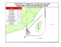
Example
-
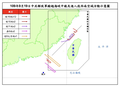
Example

Article(s): Taiwan Strait
- Request
- There is no high quality map of the median line of the Taiwan Strait on Wikimedia Commons or on Wikipedia (the only ones I can find are these I've just uploaded and added here); such a map should be produced.
- (1) Here is a pdf that shows the median line of the Taiwan Strait: [7]. (2) Here is a discussion of the median line on Wikipedia: Taiwan_Strait#Median_line. (3) Here is a Wiktionary article with five reliable sources discussing the line: [8].--Geographyinitiative (talk) 18:33, 8 October 2023 (UTC)
- Graphist opinion(s)
Gulag camps in Azerbaijan[edit]
-

Example

- Article(s)
- Stalinist repressions in Azerbaijan
- Request
- It would be great if someone create map for Gulag camps in Azerbaijan. We could use it in en:Stalinist repressions in Azerbaijan#Gulag camps in Azerbaijan. There were three camps located in Azerbaijan. First one is in Salyan, second in Baku and third one is in Goygol. See examples: Category:Gulag location maps. -- Nemoralis (talk) 22:17, 8 October 2023 (UTC)
- Discussion
- Made myself: File:Gulag camps in Azerbaijan SSR.svg Nemoralis (talk) 14:22, 20 November 2023 (UTC)
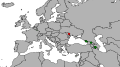
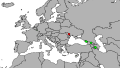
ethnic and linguistic maps of the Caucasus[edit]


Article(s): [[]]
- Request
- Please update these maps due to the w:flight of Nagorno-Karabakh Armenians. Initially, it would be better to mark this area as uninhabited, because according to the UN there are between 50 and 1,000 people left.
The second thing is to add a "spot" of Greeks near the city of w:Yessentuki to the first map.  --Swiãtopôłk (talk) 16:44, 16 October 2023 (UTC)
- All of Nagorno-Karabakh and the striped areas around it, need to be colored in striped green and white, because almost all Armenians fled the region in September/October 2023, but has still not been populated by Azerbaijani civilians in the striped areas, after Azerbaijan gained it in late 2020. The whole region is patrolled by Azerbaijani troops and police, who are the only human presence, hence why the whole region needs to be colored both in green and white stripes, rather than just in green or just in white. --Multituberculata (talk) 20:54, 20 November 2023 (UTC)
- Graphist opinion(s)
Current and former Marxist–Leninist states (North Korea to be stripped)[edit]

Article(s): en:Marxism–Leninism and related pages.
- Request
- Add a rotated (45 degrees) stripe pattern to North Korea (red and dark red).
- To reflect the lack of consensus whether North Korea is still Marxist–Leninist or not. –Vipz (talk) 18:51, 22 October 2023 (UTC)
- Graphist opinion(s)
Map of French Guyana in a book for Wikisource[edit]
-

Current state of the map

Article(s): https://fr.wikisource.org/wiki/Aventures_en_Guyane
- Request
- Hi!
 Would it be possible to enhance this image? Similar to what has been done regarding this one for example : File:Belliou la Fumée - Hachette- page 17.jpg. This illustration will be on Wikisource in French. --Tpe.g5.stan (talk) 09:41, 26 October 2023 (UTC)
 - Graphist opinion(s)
- I edited the image like the other picture you linked, but some of the writing in the image is hard to read(even in the original), so if you want i could try making a higher resolution version and re write the text so that is is easier to read :3 Done Worm-b0y16 (talk) 12:48, 27 October 2023 (UTC)
- Thanks a lot !
- On republications of this book they have completely changed the map. It is most probably the editor's work anyway (the author has disappeared/died in the forest and the book was published posthumously). I do not think it will be necessary. Tpe.g5.stan (talk) 13:14, 27 October 2023 (UTC)

Update the Map[edit]
Data - https://dahd.nic.in/hi/related-links/annex-ii-8-gist-state-legislations-cow-slaughter
-

status
-
original


- Request
- Update the map and add the states like Uttar Pradesh, Madhya Pradesh in red. Data from [9]--103.241.226.199 06:23, 3 November 2023 (UTC)
- Both maps of India also need to include the new borders of the Union Territories of Jammu and Kashmir, and Ladakh, which were created in 2019, and the borders of the State of Telangana, which was created in 2014. --Multituberculata (talk) 19:19, 20 November 2023 (UTC)
- Graphist opinion(s)
Update map of NCAA D-I men's hockey locations[edit]
-

Map showing the locations of all NCAA Division I men's college ice hockey teams

Article(s): en:List of NCAA Division I ice hockey programs
- Request
- This map needs to be updated with current locations listed at en:List of NCAA Division I ice hockey programs#Men
--R.L (talk) 17:54, 7 November 2023 (UTC)
- Graphist opinion(s)
Map of Arabian states (1905-1923)[edit]
-
Description of first image
-
Description of second image (if needed)
-
Description of third image (if needed; don't request too many at once, though)
- Article(s)
- en:Federation of South Arabia, en:Protectorate of South Arabia (and other countries in the map)
- Request
- there are no good maps in wikipedia of this region and time period and countries like yemen, saudi, transjordan, Mahra, Dhofar, Kathiri and, Quaiti don't have maps like this one on wikipedia/commons.
Here's the reference: the map -- Abo Yemen✉ 18:24, 3 October 2023 (UTC)
- Discussion
- Graphist opinion(s)
3 images need fixing[edit]
-
Artsakh needs removing
-

Saint Kitts and Nevis, Jamaica and Fiji need to be grey as they have no official Railways
-

Artsakh is being dissolved, Ukraine and Moldova have left Commonwealth of Independent States and CISFTA


- Article(s)
- en:International recognition of Abkhazia and South Ossetia, en:List of track gauges, en:Collective Security Treaty Organization
- Request
- (I have listed underneath the 3 images what needs fixing.) --HelpfulHens (talk) 16:54, 20 November 2023 (UTC)
- Graphist opinion(s)
Donetsk, Luhansk and Crimea[edit]
-

Donetsk, Luhansk and Crimea absorbed themselves into Russia.

- Article(s)
- en:List of states with limited recognition
- Request
- (Donetsk, Luhansk and Crimea come up when I hover over them but they should come up as Ukraine as they dissolved themselves.) --HelpfulHens (talk) 16:59, 20 November 2023 (UTC)
- Graphist opinion(s)
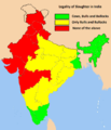
Update of the maps of India, which need to include the borders of Jammu and Kashmir, Ladakh and Telangana.[edit]
.svg)
_(claims_hatched).svg)
_(disputed_hatched).svg)
.svg)

.svg)
.svg)
.svg)
.svg)
.svg)

.svg)
.svg)

.svg)
.svg)

.svg)

.svg)
.svg)
.svg)
.svg)
.svg)

.svg)
.svg)
.svg)

.svg)
.svg)
_(claims_hatched).svg)
_(disputed_hatched).svg)
.svg)

.svg)
.svg)

.svg)
.svg)

.svg)
.svg)

_(claims_hatched).svg)
.svg)
.svg)

.svg)
.svg)

.svg)
.svg)

.svg)
.svg)
.svg)
.svg)
.svg)
.svg)

.svg)
.svg)

.svg)
.svg)

.svg)
.svg)

.svg)
.svg)

.svg)
.svg)
_(claimed_and_disputed_hatched).svg)
_(claims_hatched).svg)
_(disputed_hatched).svg)
.svg)

.svg)
.svg)
.svg)

.svg)
.svg)
_(claims_hatched).svg)
_(disputed_hatched).svg)
.svg)

.svg)
.svg)

.svg)
.svg)

.svg)
.svg)

.svg)
.svg)

.svg)
.svg)

.svg)
.svg)

.svg)
.svg)

.svg)
.svg)

Article(s): Hundreds of articles across Wikipedia.
- Request
- The internal borders of India urgently need to be updated. The borders of the Union Territories of Jammu and Kashmir and Ladakh which were created in 2019, and the borders of the State of Telangana, which was created in 2014, need to be drawn in the maps of India, which are very widely used in hundreds of articles across Wikipedia. These maps are categorized under the Category:SVG locator maps of states in India (red location map scheme). --Multituberculata (talk) 19:41, 20 November 2023 (UTC)
- Graphist opinion(s)
Transnistria maps[edit]
-
Artsakh needs removing
-
Artsakh needs removing


.svg)
- Article(s)
- en:International recognition of Transnistria, en:Foreign relations of Transnistria
- Request
- I have added the info above.
- (details of your request go here...) --HelpfulHens (talk) 20:07, 20 November 2023 (UTC)
- Graphist opinion(s)